Tag Archive for: Andrew Eberly

Words by Andrew Eberly

It’s been a few days since our first big snowstorm in a couple of years. We ended up with somewhere around 8 inches that arrived in two distinct waves of precipitation over the course of 24 hours. By now the original snowpack has melted, recrystallized, sublimed, compacted, and drifted in the wind so that we are left with an uneven 3 or so inches that still covers the entire landscape. 

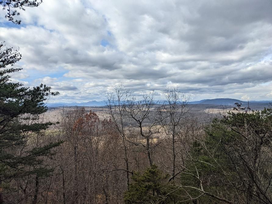
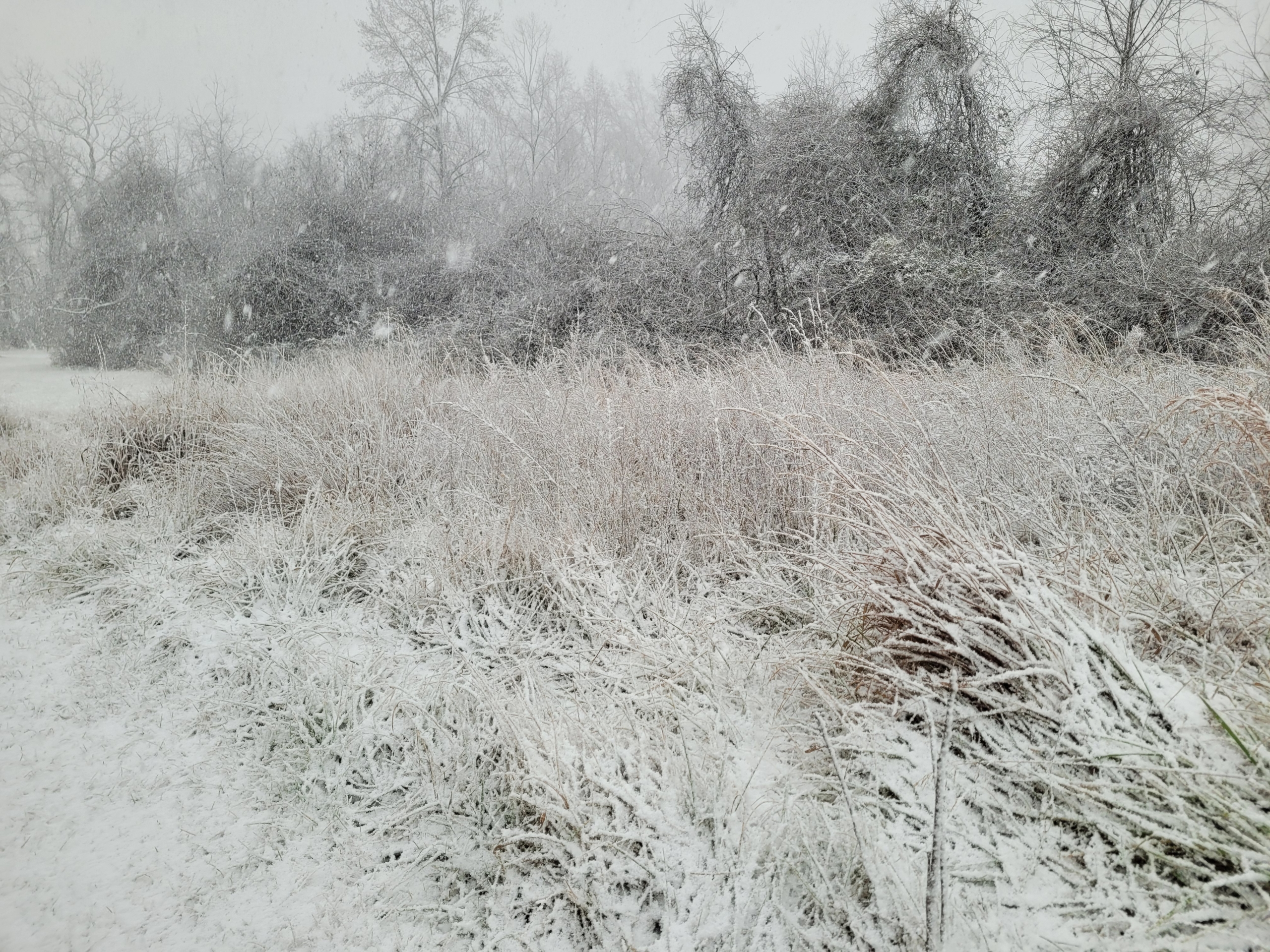
Despite the excitement of this latest storm, I would like to turn everyone’s attention to the brief but incredible blast of winter that occurred two days prior to the big storm. Friday, January 3rd began as a partly to mostly sunny day. It was cold early on, but the sun warmed up the ground throughout the day and by the afternoon ambient temperatures were well above freezing. I was out on the Big Hickory Trail scouting for the all-day hike the next day, sweating in my jacket, when the sky suddenly grew quite dark. Were we about to get a repeat of the highly anomalous severe thunderstorm event we saw on New Year’s Eve? Indeed, a sudden wind gust swept through as it might on a hot June afternoon in advance of summer storm. Instead of a warm rain, this gust front was bearing a burst of heavy snow. Soon the trees around me were obscured in the white-out and the ground was rapidly gathering a coating of little snow pellets called graupel. The graupel eventually gave way to a beautiful, fluffy, classic snow cascading out of the sky for about 30 minutes in which time we received a good inch and a half of accumulation. 

The Jan .3 snow squalls featured high winds and extremely low visibility.

This storm was what meteorologists refer to as a snow squall. That morning the NOAA forecast discussion stated that snow squall parameters were “off the charts” over the Allegheny Front in West Virginia. We now know that those parameters extended well east of there. 

Like thunderstorms, snow squalls are a form of convection. Actually, if you were lucky enough to be in Prince William County on Friday, you were treated to one of the rare holy grails for weather enthusiasts, thundersnow! We just missed it here. Convection is the rapid and concentrated upward movement of air from near the surface to high in the atmosphere with subsequent downward movement nearby to balance things out. It indicates that there is a sharp difference in temperature between the relatively warm surface and cold upper atmosphere. This unstable situation can be caused either by moving a bunch of very cold air over top of warmer air or heating the air at the surface. Both things were occurring on Friday afternoon, so convection is what we got. 

The type of cloud produced by convection is a cumulonimbus. These are tall clouds with frozen tops that are on the order of a few miles wide, a few miles high (much taller in the summer than winter), and they tend to occur in groups. Snowflakes form in convective clouds and then they get blown around inside the cloud by all the vertical air currents. As they swirl around, supercooled liquid droplets collide with the snow crystals and freeze onto the surface. Eventually they get covered in a frosty crust called rime ice. If you have climbed a tall mountain during the winter, you have probably seen objects covered in thick layers of rime ice from colliding with supercooled cloud droplets in the wind. When enough rime ice collects on a snowflake, it gets heavy and falls to the ground as a little pellet of graupel. Graupel is an indication of convective clouds. These same processes also occur in summer thunderstorms but the air at the bottom of the cloud is warm and melts the frozen precipitation. 

Clifton transformed into a winter wonderland on Jan. 3

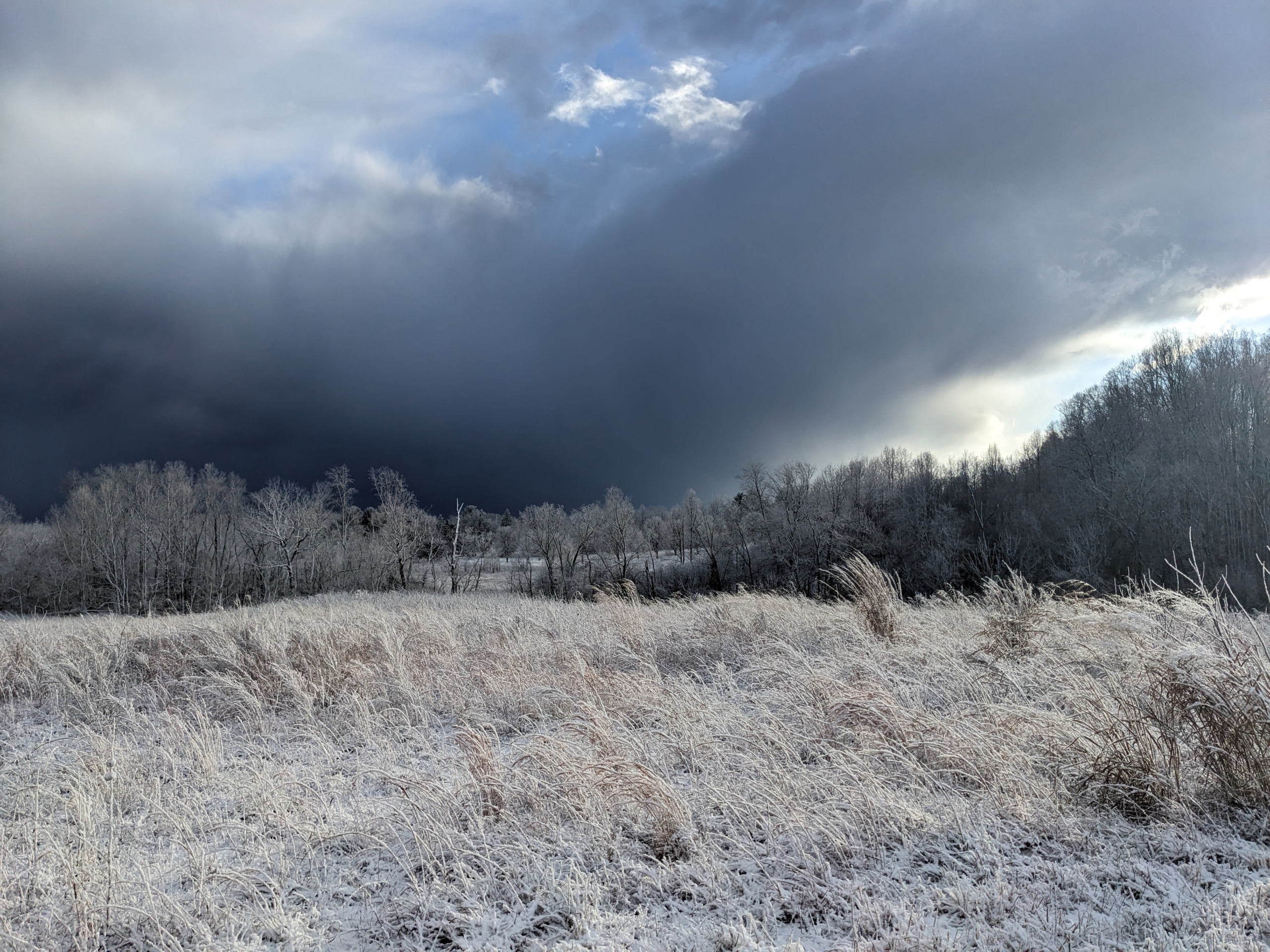
Convection typically causes heavy precipitation, but it also doesn’t last long. After the Squall on Friday the sun came out and illuminated the freshly frosted landscape. This was immediately followed by another squall, then more sun. Such is the pattern that convective events tend to follow. Bursts of rising air with sinking air in between. 

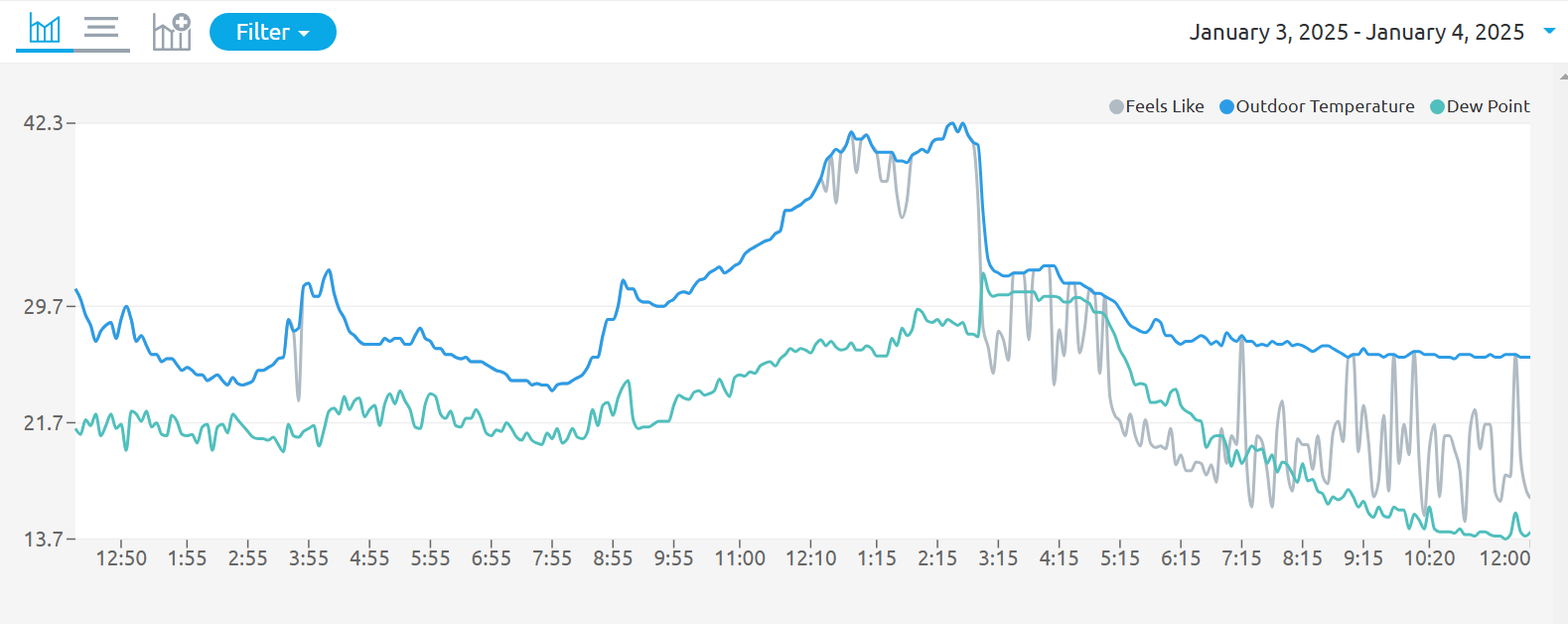
If you look at the temperature graph from the Clifton weather station for last Friday you can see that the temperature starts out quite cold, in the low 20s. After the sun comes up, the temperature climbs to a comfortable 42 degrees. The dewpoint also rises but not by as much indicating that the air is dry. Then around 3pm the temperature plummets but the dewpoint spikes briefly. This is the big snow squall. The dry air is what helped keep the snow from melting as it fell into 42-degree air. As water evaporates from the surface of the falling snow pellets or flakes, they cool down from the same process that cools you in the summer when you sweat. Eventually this cools the surrounding air and the temperature under the cloud drops. The creation of cold, dense air descending out of the cloud is also what causes the sudden wind gusts in convective events (indicated here by the even steeper drop in “feels like” temperature or wind chill). The spike in dewpoint is caused by the addition of water vapor to the atmosphere from the snow.

A graph of a stock market

Description automatically generated
The view of the farmhouse post-snow. The author returned from Big Hickory intact, and only a little frostbitten.

Habitat Specialist Andrew Eberly has many roles here, including growing seedlings for our plant sales, conducting plant and bird surveys, and helping to manage our 900-acre property. Here he shares some of the thinking that goes into taking care of our land.

Each fall I find myself out in the fields doing the repetitive, physical work of controlling the trees and shrubs that have worked their way into the 300 acres we are trying to manage as grasslands or shrubby savannas. This is time-consuming and sometimes arduous work, but it’s also enjoyable in many ways. It gives me a close look at what is growing out there and allows me time to ponder the pros and cons of the methods we are using to manage the land. What follows is a sample of some of these thoughts. To start with, there seem to be as many approaches to managing land as there are land managers and that’s OK. We are working with ecological processes that play out over tremendous periods of time and we must be at peace with the fact that a human lifetime isn’t long enough to see the results of all of our plans and hard work.

Turkey Gap in summer.

We’re all about grasslands here at Clifton. They are the most imperiled habitat we have and the plant species that comprise our remaining grasslands won’t survive if trees shade them out. The easiest thing would be to mow them short every year, but transitional habitats are also valuable. It’s a constant struggle to strike a balance between what is feasible from a management perspective and creating a mosaic of multiple successional stages.

The field we call Turkey Gap is an old pasture in the process of diversifying and reverting to a wilder type of shrubby savanna ecosystem. It’s a good example of the kind of transitional habitat that we want to make sure persists. Most of Turkey Gap gets bush hogged regularly, but for the last three years I’ve set aside a small area to see if there’s any chance of maintaining it without mowing. Mowing is a necessary tool in grassland management, but in my experience it has some downsides. For small animals living in fields, mowing is a catastrophic event. Also some invasive woody plants actually increase when they get mowed once a year. Finally, mowing has a tendency to smooth out the natural heterogeneity of sizes and ages naturally found in grasslands and shrublands.

My experiment now hosts hundreds of Tulip Poplars, Black Walnuts, Autumn Olive, and many more tree species that have already reached 15’ to 20’ in height. The result is a beautiful early successional woodland that hosts nesting American Woodcocks, roosting Red Bats, Box Turtles, and countless other animal species that seem to depend on having some scraggly, immature woodland patches within their home ranges. But soon my little section of Turkey Gap will grow up into mature forest unless I do something about it. Removing tree seedlings by hand with loppers and spraying the stumps with herbicide is the most targeted approach. Moving slowly through the habitat in this way allows me to find and avoid killing special  native shrubs like Southern Crabapple and American Plum, along with more common species like sumacs and native roses that I believe should have a place in any savanna. Basal bark spraying with herbicide is a quicker strategy I plan on exploring in the future.

Turkey Gap in fall.

Why do I have to use chemicals anyway? Most of our perennial broad-leaved plants are adapted to being broken, burned, or cut periodically and they will happily resprout repeatedly with more individual stems each time. Invasive Autumn Olive is especially good at the “hydra” growth pattern. Herbicide is necessary to prevent the trees I’m removing from growing right back. Ultimately we are trying to mimic the natural disturbances of fire and grazing, so why don’t we just burn it and put some Bison out there? We will! Well, maybe not bison. Bison are a challenge to contain and they eat mostly grass, so they are hard to work with. We do prescribed burns, but they can be logistically hard to pull off. Fires are particularly challenging during the growing season when they would have the biggest impact on tree growth. Plus, in many parts of the Clifton property–even places that get burned repeatedly–woody species sometimes keep growing and eventually dominate to the point where they inhibit the growth of more flammable grasses and wildflowers, which prevents fire from having the effects we want it to. Some spots simply don’t want to burn.

It seems that if we want grasslands and savannas alongside forests on a medium-sized property like ours we have to be a little heavy-handed. I’m all for “letting nature take its course” in large wilderness areas where there will naturally be sections at different stages of succession, but we have to work hard to create and maintain the diversity of habitats we want here.

This kind of thinking leads me to another question that I often think about when I’m out there. How feasible is it to maintain native grasslands here long-term? The Clifton Institute lies on metabasalt (greenstone) bedrock. The soil here is relatively nutrient rich and some spots hold water for a long time. There aren’t as many remnant prairies on metabasalt compared to the poorer soils to our east, apparently because most sites have been converted to agriculture. These richer and moister soils tend to benefit non-native plants, which makes my job harder.

On the Clifton Institute property, we are living with the legacy of hundreds of years of agriculture. The current placement of our fields and forests is dictated by this history, as is the species composition of our plant communities. Moving toward a diverse mosaic of habitats dominated by native species will take time. We will continue to use the tools at our disposal and take cues from the environment to guide things toward greater biological diversity. This is a process that will take many years and will hopefully extend far beyond any of our lifetimes.

Turkey Gap in winter.

Most of us living in Northern Virginia naturally break down our region into sections based on geographic, ecological and cultural similarities. The Blue Ridge Mountains form an undulating wall on our western horizon, clearly visible for many miles as a rugged line of forested mountains. The coastal plain encompasses the lowlands surrounding the Chesapeake on eastward, across the Delmarva Peninsula to the Atlantic, and everything in between we call the Piedmont.

From a strictly geographic point of view, everything below the higher peaks of the Blue Ridge all the way to the coastal plain could be considered the Piedmont, which is defined as a gentle slope leading to the foot of a mountain range. But the Piedmont of Northern Virginia is a diverse landscape that can be a little hard to pin down under one umbrella.

The Piedmont is important. A line of big cities marks its eastern edge. Why? This is where ancient crystalline bedrock first emerges from under the young, low-lying sediments of the coastal plain. Wide, tidal waters easily navigable by cargo ships encounter constricted, fast-flowing streams winding between the rocky hills. Mills requiring high gradient waters for power could load their products right onto big ships and send them across the world.

From an ecological point of view, the piedmont is a land of relatively high biodiversity. A jumble of different bedrock types, spread across a landscape of rolling hills and meandering valleys leads to diverse soils. The Piedmont’s position just below and east of the mountains makes for a milder climate with somewhat higher rainfall than areas just to the west of the Blue Ridge.

When trying to define the Piedmont geologically, things get much murkier. In fact, one could easily make the argument that everything west of a line from Culpeper to Warrenton to Leesburg is actually part of the Blue Ridge Mountains. How is that?

The “Piedmont” in these parts is actually divided into three very distinct regions geologically. To understand that better, let’s look at things in a cross section. Since the whole region is oriented from southwest to northeast, we will start in the southeast and head northwest.

As you travel 17 north from Fredericksburg, you transition from the young, undeformed sediments of the coastal plain to massively deformed crystalline rocks just west of I-95. This is a land of choppy hills, and narrow valleys. The elevation generally runs from 200’ to 400’ above sea level. The rocks under these hills are from the early Paleozoic era, when there was little life on land and the dinosaurs were still 300,000,000 years in the future.

The current hills are the eroded nubs of huge mountains from that time. Many of the rocks came from far away and were smashed onto the edge of the continent as the seafloor was subducted underneath, like how a fallen log will collect rafts of foam from the surface of a river as the water moves underneath. In Northern Virginia, this band of low, rolling hills is part of the Inner Piedmont Province. There is an Outer Piedmont farther south and east in Virginia, but it disappears under the sediments of the Chesapeake to the north.

The rolling hills of the Outer Piedmont with the Blue Ridge Mountains beyond. Between lie the lowlands of the Culpeper Basin. To me this is the most characteristic landscape of the Piedmont.

Just past the community of Morrisville, the landscape changes abruptly. The mostly wooded hills are gone and a flatter landscape of broad agricultural fields opens up. This is the Culpeper Basin. A relatively new addition to the geologic landscape of Virginia. By new, I mean there were dinosaurs walking around, and big trees, but no Atlantic Ocean yet, when this basin came into existence.

The basin is the result of a stretching force on the earth’s crust, opposite the force that pushed the rocks of the Outer Piedmont onto the eastern edge of the continent. The Piedmont rocks started to break free and slide away from the Blue Ridge Mountains during the Triassic period some 230,000,000 years ago. The gap in between was filled with sediments to form a flat basin where lava occasionally flowed across the land. The area would have initially looked like a portion of today’s Great Basin in Nevada and Utah. No major tectonic events have occurred since then and the landscape you see today is basically the work of 200,000,000 years of weathering and erosion sculpting this once dramatic rift basin.

Death Valley is an extensional rift basin in Southern California. The topography is likely similar to what the Culpeper Basin looked like in the Triassic and Jurassic periods with the Blue Ridge on one side and the Inner Piedmont on the other.

Just before you reach Warrenton, the landscape changes again. Hills once again dominate the scene. These hills are somewhat broader and taller than those of the Inner Piedmont. They are the remains of lava flows that occurred more than 530,000,000 years ago. The lava was metamorphosed into the greenstone of the Catoctin Formation. This rock is very resistant to erosion and stands high in ranges like Pignut Mountain, where The Clifton Institute is located, and the Watery Mountains just to the west. If you were to stand on the summit of these hills and look northwest, Catoctin Greenstone would also form the higher ridges on the western horizon. In fact, it used to cover everything in between but has been removed by weathering like a giant ice cream scoop, to reveal even older rocks underneath.

Standing on the Catoctin Greenstone of Wildcat Mountain looking west. Catoctin Greenstone also sits atop the high ridges of Mt. Marshal on the horizon. The whole scene is part of the Blue Ridge Anticlinorium.

The rocks under these mountains originated along the eastern edge of North America before the Inner and Outer Piedmont terranes came crashing in and long before the rifting of the Culpeper Basin. The whole slab of rock between Warrenton and Luray was shoved westward some 60 miles from its original position when Europe and Africa collided with North America, detaching it from its roots deeper in the crust and forming what is called a thrust sheet. The whole unit is called the Blue Ridge Anticlinorium or just the Blue Ridge Province.

The 3 geologic divisions show up well on satellite imagery. The mostly forested hills of the Inner Piedmont (outlined in purple) are dark green. The lighter swath of farmland and urban development to the west is the Culpeper Basin (outlined in orange), dark areas in the basin are forests covering lava flows where the soil is too rocky for farming. The Blue Ridge Anticlinorium is a mosaic of forested hills and fields bounded on the west by the higher mountains of Shenandoah National Park (outlined in blue.)